
The Virunga Mountains
The Virunga Mountains
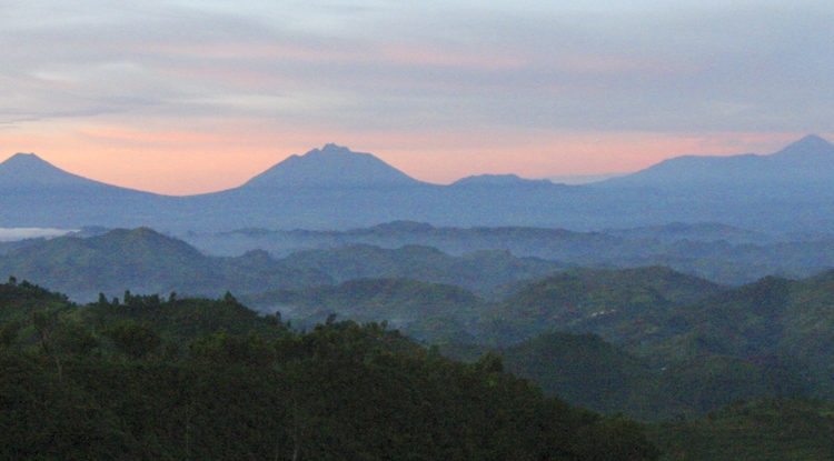
The Virunga Mountains are 8 famous volcanic mountain spread out in the Albertine region. The Virunga Mountains are commonly known as Birunga Mountains in the area by the local people or the Mufumbiro Mountains basing on the smoke that active volcanic mountains produce. Mufumbiro in the local dialect in the region means kitchen or something cooking thus the nickname. The Virunga Mountains are spread out on 80 kilometers along the country borders of Uganda, Rwanda and the Democratic republic of Congo.
The mountains start from the east up to the west at the right angle to the Albertine rift valley which is also where the Lake Kivu and the Lake Edward are found. This rift valley is a 4,000 mile long one stretching from the Gulf of Aqaba via the Red Sea to the Ethiopian plateau. The Virunga Mountains are 8 and these are the Mount Karisimbi, Mount Mikeno, Mount Muhabura, Mount Bisoke, Mount Sabinyo, Mount Gahinga, Mount Nyiragongo and the Mount Nyamulagira. The mount Karisimbi is the highest of these ranges at 14,787 feet which is approximately 4,507 meters and the lowest of these volcanic mountains is the very active Mount Nyamulagira standing at an elevation of 10,031 feet which is approximately 3,058 meters in elevation.
All these eight above mentioned volcanoes have had volcanic activity in the past years however only 2 are currently active. The Mount Nyamulagira and the Mount Nyiragongo are the only of the Virunga ranges that are still having volcanic eruptions as the last experienced volcanic eruption was experienced from the Mount Nyiragongo in May 2021. The Mount Nyiragongo and the Mount Nyamulagira are also considered to be the most active two volcanoes in the region and are responsible for 40% of the volcanic activity in the entire Africa.
The other six volcanoes are currently considered dormant as they haven’t had any volcanic activity in many years. The Mount Mikeno and the Mount Sabinyo are the oldest of the Virunga Mountains as they are said to have existed way back like 2.6 million years ago and their lava crater lakes have forever been empty and severe impacts of the elements of earth have caused the peaks to cover up.
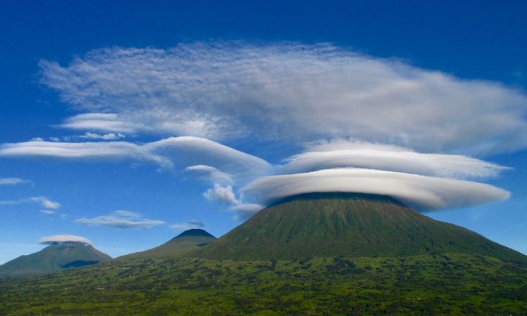
The Mount Karisimbi, the highest Virunga peak, the Mount Bisoke, Mount Gahinga, and the Mount Muhavura appeared with a crater at the summit and the Karisimbi is the unique one with no crater at the summit. The crater of the Muhabura has a crater lake at the top that you get to enjoy on a hike up the mountain. The Mount Nyiragongo and Mount Nyiragongo about 20,000 years ago is when they emerged with lava crater lakes at the top.
The crater at the top of the Mount Nyiragongo is the world’s largest lava crater lake with a width of about 2 kilometers with an uncertain pool depth that changes every time after a volcanic eruption. The Mount Nyiragongo’s first recorded eruption was in 1912 with others in the 70s and in 2002 with the last recorded in 2021 that has left the lake empty with fear of dormancy but it is still too early to conclude on this.
The volcanic eruptions of the Mount Nyiragongo have destroyed property up to the Goma town and claimed lives of the people staying in the region while leaving some homeless. A drive in Goma town gives a closer look at the effect of this Nyiragongo volcano.
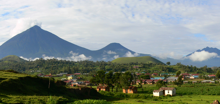
The Virunga mountain were first noticed by a British explorer called John Hannington Speke who spotted these ranges from a distance in 1861 and another British explorer called Sir henry Morton Stanley got a closer look of a few of these volcanos. These mountains were known by the people of Rwanda, Uganda and DR Congo who are living near and on the slopes of the mountains because of the fertile soils in the area facilitating their economic activity, farming.
There are 3 national parks that you can visit to get a chance to hike up these volcanoes and these are Virunga national park in the DR Congo to hike up the Mount Nyiragongo for an overnight hike, the Mgahinga gorilla national park in Uganda for a Mgahinga hike and Mount Muhabura up to the crater lake at the top and the Volcanoes national park in Rwanda for a hike up the Mount Karisimbi overnight hike or a hike to the Muhabura, Bisoke or Gahinga.
The region where the Virunga Mountains lie is commonly known as the Albertine region and is the second place where the endangered mountain gorillas can be trekked. The mountain gorillas are also famously trekked in the Bwindi Impenetrable forest national park of Uganda.
The Virunga Mountains: Virunga Volcanoes is a chain of about 8 volcanoes. They are located in the East African Rift Valley and it is alleged that they are park of this Rift.
The word “ibirunga”(comes from Kinyarwanda dialect) which literally means “Mountains” is where the word Virunga is derived.
The Virunga area like i said has 8 volcanoes located between Lake Kivu and Lake Edward. These Mountains include: Mount Nyamurangira 3058 meters, Mount Nyiragongo 3470 meters, Mount Gahinga 3470 meters, Mount Bisoke 3711 meters, Mount Sabyinyo 3611 meters, Mount Muhabura 4127 meters, Mount Mikeno 4437 meters and the highest Mountain Karisimbi 4507 meters.
These volcanoes are also home to the endangered mountain gorillas. Volcanoes National Park is home to 5 of the 8 volcanoes. 3 of these volcanoes are still active and the rest are dormant.
Most of these mountains are individually coned comparing with other normal mountains. the names of these mountains are also derived from their geological characteristics for example Sabyinyo which means the old man’s teeth; it actually looks like the old man’s teeth.
There are a lot of recreational activities you can do. You can actually hike these mountains. There are mountain gorillas on the slopes of these mountains. you can visit the local communities that in habit on the sloped of the mountains, most of which were resettled out side these areas like the Batwa people.
Virunga National park safaris
10 Days Virunga Rutshegura expeditions